
One interesting fact about this day's ride was that I had recently done a good deal of it. The day before Thanksgiving, I had ridden from Santa Barbara to Woodland Hills, 98 miles, in one day. About 30 of those miles I would do again today.
These are 30 not very interesting miles. Most of these miles are either directly on 101 (6 miles) or right next to it on frontage roads. When the road gets down to the water level, there are RVs or homes between you and the ocean.
One good thing is that just above Ventura is a long bike path (which is right below the freeway) that provides some respite from RVs, SUVs, and diesel generators. But, that is getting a bit ahead in the story.
I took Santa Barbara city streets through downtown to the base of Stearns Pier. There is a bike path that goes along the beach and took me under 101. Once on the other side of 101, I went through Summerland and the short but steep Ortega Hill. After the hill, the view turns to orange groves, a polo club (where there was some kind of tournament going on), semi-industrial buildings and strip malls. After several miles of this, I got to Carpenteria. Keep in mind that all this is done on roads right next to 101.
At Carpenteria, the road again goes under 101 and I headed into the small town. After going through the suburban "outskirts" of Carpenteria, I turned right on street with lots of shops on it.
I had only ridden about 15 miles and I wasn't all that hungry, butI knew that this was my last chance to get any food for many miles and I decided to see if I could find a Chinese restaurant. While there were lots of eating places, none was Chinese. I was almost to the beach (Carpenteria State Beach) and ready to turn around when I saw a Thai place. I ate two platefuls of food which was the best meal I had on the entire trip!
After Carpinteria, the road quickly gets back to shadowing 101. About 3 miles out of town, the charade ends and I had to actually go up an on-ramp and onto 101. It isn't a welcoming place. Being that close to cars going that fast made me anxious. After surviving Big Sur, I didn't want to get squashed by some out of control driver on the side of 101.
The bikes have to exit at each off-ramp and then re-enter on the following on-ramp. For much of this freeway ride, the road is right next to the ocean. Given that much of my riding was next to the ocean, there was something very Southern California about riding next to the ocean but being on a freeway.
Riding on 101 seems dangerous. The bike lane is adjacent to the right hand traffic lane. To the right of the bike lane is a place for cars to park to access the beach. The beach is just beyond a retaining wall and there were surfers in the water.
While I was riding on 101, a biker waved me down and asked if I had a pump. He had a flat and a tube repair kit but no pump or spare (go figure!). I stood on the side of 101, cars and truck zooming by while this guy glued patch after patch on his tire, which wouldn't actually hold air. He gave up after about 10 minutes and I pedaled on.
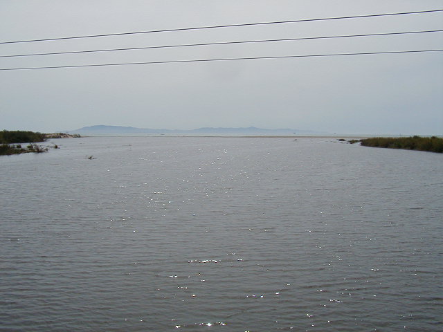
After 6 nervous miles, I exited 101 and followed Highway 1 along a set of railroad tracks just below 101. For the most part this was deserted land on one side with the occasional expensive tract of homes on the other. Here is a typical view looking South. Fittingly, the RV you see is on 101.
Here is a view looking back.

After about 10 miles of this road, several of which was riding next to a full RV park that is right next to the ocean, I entered a bike path. The path seemed to be part new and part existing highway. This was much more peaceful, though 101 was never far away. Here is a view of the ocean and islands from that path.

The path eventually runs into Emma Wood State Park, which closely resembles a long parking lot. Around a corner is a series of private campgrounds. The bike path (now on a road) crosses the Ventura River and winds around into Ventura. The path continues through an interminable set of parking lots which eventually dumped me out in a vacation beach area. I wound my way through the cottage-lined streets and eventually got onto Harbor Blvd, a huge road with a good shoulder.
I continued on Harbor Blvd. for quite a while, eventually going over the Santa Clara river.
Just over the Santa Clara river is Gonzales road. That is where I turned left in November and rode off to eventually climb over the coastal hills on Santa Susanna Pass just outside Simi Valley. That, however, was all in the past. Instead of taking a left, I continued on Harbor Blvd and went past a large deserted sandy area where the wind was beginning to blow. I also passed a huge power plant right next to ocean. It smelled and was visually ugly and imposing. Slowly, this desolation gave way to the housing tracts of greater Oxnard.
Oxnard gave way to Port Hueneme, an unappealing burg that abuts a Naval base. I rode along a chain link fence, past guarded base entrances, and by a deserted golf course all on a shoulderless road full of cars. I turned right at the end of the golf course and followed the fences for several more miles. The road here was so narrow that I decided to ride on the sidewalk, which was full of tree limbs blown down in recent wind storms.
This are also had lots of what, to my eye, looked like military housing and apartments. By this time I was getting tired, both of riding and the scenery.
At the end of the Naval base, a right turn sent me on a 5 mile run into huge agricultural fields. The road had a nice shoulder and the highway was deserted. Eventhough the views were monotonous, I felt a lot better than riding through Port Hueneme.
After the long agricultural stretch, this road skirts the Naval Air Station, complete with replicas of air-fired missles (arranged in chronological order) and attack aircraft. Given the war in Iraq, it was a bit sobering to see all that hardware on display and wonder what it would be like having it fired into my neighborhood.
Finally, after passing more military housing and the last entrance to the Air Station, the road again got to the coast as Point Magu, pictured below.
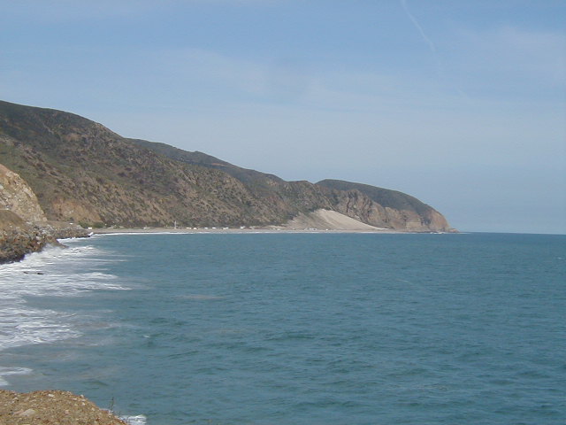
As you can see, the road is right on the coast. However, the view is quite stark and not all that inspiring. Especially to someone who has just ridden through lots of ugly urban landscape to get there.
At one roadside rest stop I decided to take a picture of the cliff on the other side of the road just to make clear what the view was for the last few miles of this day's ride.

About 5 miles south of Point Magu is Sycamore Canyon State Campground, my destination. I arrived about 5 pm to a mostly empty campground. I chose a camp site just beyond the hiker/biker site, in case I was questioned about the $3 fee I paid at the deserted ranger station. Not surprisingly, the camp site is in a canyon studded with huge sycamore trees! Eventhough, I was right off the road, I couldn't hear it and there were lots of chirping birds and hares around.
After setting up camp, I took a shower and then relaxed in my tent.

Dinner was 2 peanut butter sandwiches, lots of M and Ms, gatorade, and other snack items I had in my bags. Shortly after dark, I went to sleep.